How We Do It

Helical Pier Tiebacks
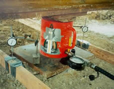
Pile Load Test
Site characterization
This is the first step in geotechnical and environmental assessments. Our objective is to obtain adequate information to meet the client’s needs in a cost-effective manner. This involves more than just drilling holes.
Geologic Setting
Site characterization starts with knowing the geology and potential problems in advance. PCC maintains geologic maps, soil maps, topographic maps, in-house databases, libraries and electronic references with thousands of test borings and laboratory test data. These tools are used in combination with the extensive local experience of our professionals. This is why we prefer to utilize our experience to design the exploration and testing program.
Subsurface Exploration and Testing
Geotechnical exploration usually includes test borings with Standard Penetration Tests (SPT) at regular depth intervals. This type of exploration provides data at the depths and locations tested. Shelby tube samples, bulk samples, core samples, liner samples, etc. may be utilized to obtain samples for specific types of testing. Laboratory tests are usually performed to evaluate material properties. In-situ testing may include specialty methods such as dilatometers, pressuremeters or inclinometers. Specialty methods such as shear wave, seismic surveying, ground penetrating radar or others may be used. Test pits and hand auger test borings with Dynamic Cone Penetrometer (DCP) testing, Shelby tube and/or other sampling and testing techniques are often used for projects involving forensics. Direct Push sampling is often used for environmental sampling.
Stratification
PCC geotechnical reports often include geologic cross sections similar to the examples shown below. Our interpretation of subsurface conditions may be illustrated by separating soils and rocks of similar engineering properties into strata. Vertical and horizontal variations are typical. Strata changes may be gradational or inter-bedded. The engineering properties of interest depend on the particular project; therefore, strata may be drawn differently using the same data. For example, the characteristics of interest for construct of a dam may be different than for support of a building or road.
project characteristics
It is of little value to drill test borings 15 feet deep if the basement floor will be 20 feet below present ground surface. It is not necessary to drill 100 feet deep if it is a light-weight structure in an area known to have relatively good soil conditions. As explained on what we do, we prefer to develop a program for the specific project. To do this, we need project information such as site plans with proposed building, pavement and storm water management facility locations and elevations, and preliminary structural loads. We do not need final drawings, but we need as much project concept information as practical for the stage of planning.
Data Interpretation and Calculations
There is often more than one possible interpretation of the same data. Our professionals have a lot of experience in the local area, which is a key factor. Calculations may include bearing capacity, settlement, earth pressures, global stability, lateral capacity, groundwater seepage and many other subjects, some of which have been developed by us for specific applications.
Reports
Our reports typically include data developed by our research, site visits, subsurface exploration, laboratory testing, calculations, professional opinions and recommendations. Specific items addressed are tailored for the project and agreed upon scope of services.